(Subtitled "Why write these things if you don't take any notice of them?")
THE "APPROVED"
DEVELOPMENT |
||
| 3.7 "These policies will seek to ensure that the form, density and character of new housing is in harmony with adjacent housing..." . |  |
|
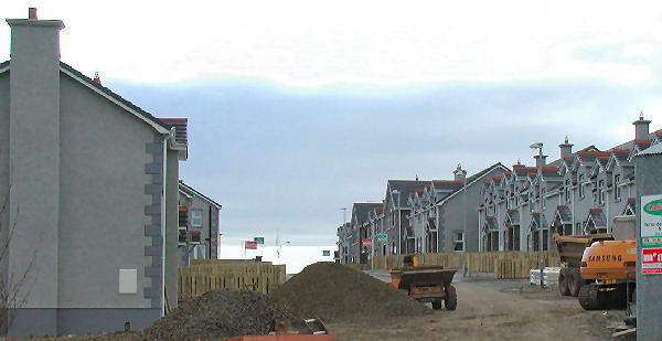
| All existing Eagry properties are bungalows . But the new dwellings which abut onto these are all two storey, including two sets of terraces. Photo (taken 13 Nov. 04) shows the first dwellings to 'raise their heads' over the existing bungalows on the Straid Rd. And there's worse to come as there is to be another set of terraces built even nearer, and on higher ground, to the back of these bungalows. | ||
4.5 "It is important that the new residential development is based on a clear design concept. Ideally this should be based on a network of spaces rather than a hierarchy of roads." |
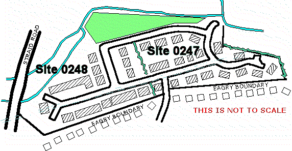
See the rough layout sketch several panels below. | |
4.13 In all cases developers will need to demonstrate that their proposals will avoid significant ... overlooking and loss of privacy. |
||
Incidentally the very first dwellings to be built on this site were of the wrong house type (MD41) with windows which also overlooked existing properties. |
||
|
||
QD1(h) "All proposals for residential development will be expected to conform to all of the following criteria.:- " There then follows a list which includes...." and there is no unacceptable adverse effect on existing properties in terms of overlooking ...." (Winner of the 'How many negatives can you get in one sentence' competition) This works the other way around too! Because of the sloping site, many of the existing Eagry bungalows abutting the new dwellings are approx 2m above the new development and many of them will be looking down into the new gardens, into the rear ground floor rooms and directly from their kitchens into the new houses' bedrooms How can a developer prove "no adverse effect on existing properties" when only two of the 20 existing Eagry properties which abut the site appear on any of the submitted plans? |
|
|
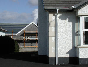
| By the way the finish for that building being built in the background was agreed between the Planners and the developer as to have black fascias and brown windows. Observant viewers will note both fascia and windows are white! | ||
| 4.3 "... it promotes biodiversity and encourages wildlife" | The planners have passed the layout which covers over valuable wetland and has also ignored a requested by DOE HS. for a 10m wildlife corridor. | |
| 4.8 "... particular account will be taken of the spacing between buildings, .....the scale and massing of buildings." | 16 of the dwellings (nos 1-16), consisting of 6 semis and two terraces, form an almost solid "wall" of nearly 130m backing onto the rear of the Eagry dwellings (two gaps of 5m; one gap of 3m and one gap of 2m) | |
4.13 Particular care will be necessary in preparing layout proposals on sloping sites in order to minimise the impact of differences in levels between adjoining properties, existing or proposed.... Developers may also wish to consider the use of specific house designs ... such as split level dwellings. |
0247 and 0248 are sloping sites - particularly 0248 Nope. Not a single split level dwelling in this development. |
|
| 4.30 Regard should always be given to ways of integrating pleasant, attractive and landscaped areas of public open space, including children's playspaces. Open space not only has recreational and social value but it is also considered vital to the overall design quality of the development | To me the open space in this development (see general sketch below) does not appear to be an "integral" part of the estate within the dwellings, but is "bolted on" to the periphery (which just so happens to be where the land floods!). See Flooding photo of this open space (opens in separate widow) However there are a great number of trees recommended and the slightly wider street running east to west shows a short avenue of trees. | |
Yet in the list of agencies accepting the proposal we find the following statement under the Layout Issues:- "The application was assessed at our internal meeting on 17-NOV-2003 by a board of planners against our Housing Policy (Planning Policy Statement 7: Quality Residential Environments) and found to be acceptable." |
||
| Referring to the above PPS7 guidelines, the Latest APPLICATION FOR PERMISSION TO DEVELOP LAND Form P1 states..."Applications... must include a site appraisal/analysis and a resulting concept plan and statement placing the development in its context and demonstrating how the design and layout have been conceived " | As far as we can discover, by looking through the public Open Application Files, there as no analysis; no context statement; no demonstration re how the layout was conceived. All totally ignored and what's more - not even asked for by the Planners. There is, however a concept plan. Which was so superseded as to be rendered a waste of paper. | |
| And here's another set of recommendations. This time the extracts are taken from a glossy 27 page booklet entitled "Improving the Quality of Housing Layouts in Northern Ireland". Jointly sponsored by the Planning Service; The Roads Service; The Housing Executive and the Construction Employers Federation of NI. It is undated!! (You would think someone amongst such an erudite group would have spotted this oversight) . However from the following remarks, I'm guessing it was published in 1999. (Can anyone help to date this?) | ||
"IMPROVING QUALITY
OF HOUSING" |
THE "APPROVED"
DEVELOPMENT |
|
| Here's a couple of quotes from the 'blurb' in the front :- "We are in a position to harness the imagination, vision, abilities and integrity of all involved in the development process. As we enter a new century, let us work positively towards creating sustainable quality environments that will contribute to a better life for all - now and in the future"....."How often do we hear calls for the return of treelined avenues ... and for some relief from the monotony of rows of same or similar houses?" NEW See below for photo of 'monotonous row of similar houses' on this development. | ||
 |
||
Photo
taken on 25th February 2006 |
||
| NEW - See also photos below taken of rears of this development, Feb 2006, showing how they face onto one of the tourist routes to Ballycastle and also demonstrating how the dwellings differ in numerous ways to the submitted and approved plans. | ||
| P5. A well designed housing layout...should provide variety and contrasts. The spaces between houses should not then be mere standard streets and culs-de-sac, but avenues, squares, crescents, mews, courtyards, lanes, alleys and greens" | See the rigid, straight, angular layout in the sketch below. And the photo above. Nuff said. | |
| P14.
If designers rely on one or two
standard (traffic) calming devices they will emphasise the uniformity
of suburban spaces. P24. We now understand that traffic calming does not need to rely on unsightly physical devices that are visually dominant. |
I think there are seven ramps proposed in this layout. | |
 |
||
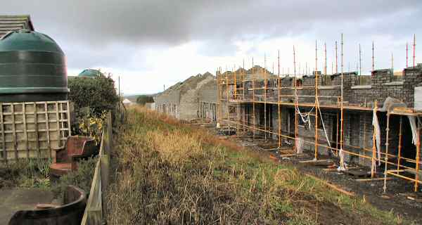
 Photo
shows scaffolding around the first floor window of a new construction.
with an existing Eagry bungalow in the foreground.
Photo
shows scaffolding around the first floor window of a new construction.
with an existing Eagry bungalow in the foreground. | The 1998 Planning Policy Statement Number One lays down the "....general principles that the (Planning) Department observes in ....exercising control over development". Let's see how this development matches up to those guidelines. Here are the notes from one single paragraph (No. iii) in Annex 3: Design. | |
PLANNING POLICY STATEMENT Number 1 (1998) |
THE "APPROVED" DEVELOPMENT |
| (iii) Applicants for planning permission will be required, as a minimum, (to) provide a short written statement setting out the design principles adopted as well as illustrative material in plan and elevation. ....... | We have trawled through the Application Files but cannot find any "short written statements" . Though there are elevations of the house types |
(iii).......This
material will show the wider context and not just the development
site and its immediately adjacent buildings. ........ |
The supplied layout plans show only two of the twenty houses in Eagry which directly abut onto this development. So we have to guess what is to be built behind us. (See Plans page) |
| (iii) .......Inclusion of relevant perspective views can also be of value. Such material will be particularly important in relation to complex or large-scale development proposals, and those involving sensitive sites. ........ | We have trawled through the Application Files but found no perspective views. |
| (iii) ..........drawings
of the proposed design itself and, where appropriate, plans of the
proposed layout in relation to neighbouring development and
uses. (My emphasis) |
Yes there are drawings of the house types, but again no plans showing the layout in relation to neighbouring development. |
| The following is an extract from the first paragraph of this Annex 3 : - | |
| (i) Plan policies ... will concentrate on guiding overall scale, density, massing, height, landscape, layout and access of new development in relation to neighbouring buildings ... | Massing = See "Wall" of terrace and semis planned Height = Existing bungalows abut onto new two-storey . But who cares about height when the very first semi built was approximately three feet taller than the approved plan? (Update. This has now been rectified) |
| And in a separate paragraph under "Sustainable Development"
we find :- 12. ....the Department will aim to ...conserve both the archaeological and built heritage and natural resources (including wildlife, landscape, water, soil and air quality)...... |
The Decision Notices have ignored pleas from the DOE Natural Heritage that there should be 'no infill, development, fencing, ground disturbance or re-seeding takes place within the 10m zone.' Only the fence has been dropped but an embanked road together with some building work has been allowed right over this wetland and almost up to the stream edge. Part of the 10m wildlife corridor zone has been dismissed and swallowed up. |
| From the same PPS1 :- 20. Particular weight will be given to the impact of development on existing buildings. ... |
All existing Eagry buildings which abut onto the site are individual bungalows. Yet all the proposed new dwellings on this interface are two storey buildings. Many are semi detached and two are terraces. (one x 6 and one x 4). |
| Here are some extracts from yet another booklet.
"Creating Places" (Achieving quality in residential
developments) published May 2000 by Planning and Roads
Services. To quote the 'blurb' in the front :- "This guide describes the contributions to quality and sustainability that developers in Northern ireland will be expected to make through design of new residential developments. It seeks to ensure that what is designed and built today will be cherished by both present and future generations" |
|
"CREATING PLACES"
RECOMMENDATIONS |
THE "APPROVED"
DEVELOPMENT |
| 1.17 Plans should show the locations and types of existing dwellings both on and in the vicinity of the site-..... . This may affect the dwelling mix required in the development. | Of the 20 existing Eagry houses which abut directly onto the site only two are drawn in the layout plans |
| 3.03. Establishing an appropriate design concept is a critical element in the design process. Typically it will take the form of a diagrammatic illustration outlining the potential to make the most of the site and its setting and should be supported by sketch plans and a written statement setting out the overall design concept and objectives for the development. . | Having trawled through the "Application Files" on numerous occasions we have not found any "diagrammatic illustrations" (only layout plans) Nor any sketch plans. Nor any written statements . |
| 7.04 Developers should examine the need to include an element of affordable housing in their plans where a social need is identified. | Is there a social need for housing in Bushmills? Perhaps Moyle District Council could answer that question. After all, this development was unanimously passed by the councillors yet it contains not a single one or two bedroom apartment/dwelling. Of the 66 dwellings, 48 are three-bedroomed and the rest four-bedroomed. |
| 3.32 An even distribution throughout the layout of developers' standard ranges of dwelling designs should be avoided | In July 2001 a member of the Planning Development Team wrote..."There is a continued use of standard house-types, which have featured widely in other locations". Twenty six (26) of those dwellings on the original proposed plan were of house type MD41. Planning Service has now approved a Layout which includes 24 type MD41 Just two less. And I have not even included the mid-terraced houses which include many more of this same type lumped together. |
| Appendix B. 1. The information to be submitted to the Department when planning permission is being sought will not exceed what any developer who pursues quality in design will normally need to produce, namely:-there then follows four bullet points, one of which is:- axonometrics, perspectives or other visual media such as photomontages to give an accurate impression of what is being proposed. | None of these graphic types appear in the "Application Files" |
NORTHERN AREA PLAN 2001
ISSUES PAPER |
THE "APPROVED" DEVELOPMENT |
4.8.2
River flood plains should be maintained free from development
led infill to preserve their natural function as flood
relief pondage areas. |
Rivers Agency has allowed the developer to infill and raise the ground in the flood plain by about 2 metres, and to build the road on top of that. Parts of some of the houses will also be on the edge of, and within, this area that floods. |
A PLANNING STRATEGY FOR
RURAL NORTHERN IRELAND |
THE "APPROVED" DEVELOPMENT |
| Published 1997 and is being superseded. However, it was quoted in May 2002 by Planners when turning down the first amended plan. | |
| Policy Con 1. The Department will bear in mind its commitment to the wise use of wetlands in considering any applications relating to any wetland site...." | Most of the wetland on this site will be covered over with an embankment road and some building. |
| Policy Con 2. Wildlife habitats and physical features con sometimes be protected by the careful siting and treatment of developments. In some cases conditions will be attached to a planning permission to minimise or compensate for the impact on wildlife or physical features. | The plea for a 10m wildlife corridor by EHS Natural Heritage has been totally ignored and construction allowed to take place within this tree belt. |
| Policy PSU 10. There will be a general presumption against development, including raising of land, where such development ..... Would be at risk from flooding. [and] Would be likely to increase the risk of flooding elsewhere. | Rivers Agency has agreed to building a road within an area which (by their own admission and plans) floods, and also allowed some of the proposed dwellings to encroach into this flood plain. |
NATURAL HERITAGE STRATEGIC PLAN |
THE "APPROVED" DEVELOPMENT |
| 2.1.
Regulation of Development "We have a significant influence on the planning process through the planning applications we receive for consideration and comment" |
The plea for a 10m wildlife corridor by EHS Natural Heritage has been totally ignored and construction allowed to take place within this tree belt. {Not much "significant" influence there then!] |
| CHARTER STANDARDS STATEMENT (undated) | THE "APPROVED" DEVELOPMENT |
| Part
2 Dev Control.
"When
a Planning Application is amended in a significant way , the Planning
Service will tell those neighbours already notified and people
who have already commented. Substantial change normally involves the
submission of a revised application" |
Of
the 26 proposed new dwellings which directly abut onto the established
Eagry dwellings, 21 of them have been changed from the published version.
(17 moved nearer and four moved further away) |
CORPORATE & BUSINESS PLAN |
THE "APPROVED" DEVELOPMENT |
| Annex 2 - Targets "75% of all decisions to issue within 28 days of final District Council consultations." | Moyle Council were consulted, and agreed, in November 2003. The decisions were issued June 2004 (over seven months later) |
| And what about advice from their own Officers? Here are written notes made by a Senior Professional and Technical Officer who was a member of the Planning Development Team. He is writing in July 2001 about the original plan in a report to the Case Officer. | |
"There
is a continued use of standard house-types which have featured widely
in other locations" |
In the plan to which he refers there are 26 of type MD41 in a proposed development of 73 dwellings. In the 'Accepted' plan the total number of dwellings have been reduced to 66 but there are still 21 of type MD41. |
| When we queried this with the Divisional Planning Manager. She wrote ... "It is not unusual for developers to re-use house types that have previously been constructed on other housing sites. The comment made [by the SPTO]... could not be interpreted as a complaint, more an observation" (MY EMPHASIS) | |
| "...Although a relatively small site, in context of Village Conservation Area, and given physical constraints, I recommend this be subject to a full site /context analysis and concept statement before any further consideration. " | As far as we can discover by trawling through the "Application Files", this analysis and statement never materialised. At our meeting with the Case Officer on 27 May 2004 we asked that this omission be confirmed. He contacted the Divisional Planning Manager but as of October 17, 2006 we have not had a reply. |
| "I
would not consider the present proposal appropriate
- view right across the rear gardens from the Straid Road" SPTO 23-07-01 |
There were 12 rear gardens facing the Straid Rd on
that original plan which he considered 'not appropriate' . Three amendments later and the "Approved" plan now has 16 rear gardens- i.e. even more!- facing the Straid Rd. See photo below |
| Photo below taken February 2006 from the Straid Road showing the rear of some of the newly built dwellings. This view of the back gardens was taken from one of the tourist roads leading to Ballycastle. By the way the submitted plans (passed by Planning) said the exterior of these dwellings were to be painted pale yellow. Wonder what happened to that idea? CLICK to see detailed photos of more of these dwellings. WHICH ALSO DESCRIBES HOW THESE DWELLINGS DIFFER IN MANY OTHER RESPECTS FROM THE ORIGINAL PLANS SUBMITTED AND ACCEPTED BY THE PLANNING SERVICE(opens in separate window) | |
 |
|
NEW 25/7/05 |
THE "APPROVED" DEVELOPMENT |
When submitting a Planning Application one is required to ..." show clearly... materials to be used in the external finish of walls and roofs and their colour. "
So the question arises... Why does the Planning Service require details of external finishes if no-one (Developer, Builder, or Planning Enforcement) adheres to the approved colour? And in a letter to us about a separate issue the Divisional Planning Manager wrote..."Planning Service require the submission of house types for three purposes. To ensure a range of house types; check footprint v site curtilage; ensure elevation detail is acceptable… (my emphasis) |
FASCIA BOARDS All the drawings submitted
by the developer and the "Schedule of External Finishes"
showed black fascias. These were approved by the Planning Service. WINDOW FRAMES. The submitted and approved drawings for terrace
sites numbers 3,4,5,and 6 show brown windows. And the Enforcement Department's reaction to the above "transgressions"? "The department considers these breaches are of such a minor nature it would not be expedient to instigate any enforcement" As well as the above changes, the exterior finishes of all the
buildings in the above Feb 2006 photograph were submitted
to, and passed by the Planning Service, to have "pale yellow
render with black plinths" See "Enforcement" pages for more details and examples |
 |
|
And in the same leaflet we find... "Plans and drawings must show clearly - Proposed layout of the site; and - elevation details of what the development would look like" So there you are - send in what plan you like, get it approved - then build something different and everyone is happy! |
Drawing Number 08 Type I, received by Planning on 5th November 2003 and APPROVED by them on 29 th June 2004, shows a terrace with two large arches for vehicles, placed side by side. But in reality only one arch has been built. The "Enforcement" department's reaction to this was as above... "The department considers these breaches are of such a minor nature it would not be expedient to instigate any enforcement" |
| 25/7/05 THE DECISION NOTICES Issued for this development states... |
THE "APPROVED" DEVELOPMENT |
| All planting incorporated in the stamped approved landscape plan (Drg16) ... shall be carried out in full in the first available planting season following commencement of the development or before occupation of the first dwelling, whichever is the latter. | The development was commenced January 2004. Planting eventually started in Jan 2006. Incidentally some 20m of established hedging, scheduled to be retained in the landscape layout, has been ripped out. |