"The
central concerns of the planning system are to determine what kind
of development is appropriate, how much is desirable, where it should
best be located and what it looks like" PLANNING
POLICY STATEMENT 1 Pub March 1998 |
As far as we can ascertain there never was a full site/context analysis and concept statement given. We asked (27th May 2004) for this ommision to be confirmed. As of 01-Jun-2006 we have not had a reply..
So in the above note we have a member of the Planning Development Team assessing that ..."There is a continued use of standard house-types, which have featured widely in other locations". Twenty six (26) of those dwellings on the original proposed plan were of house type MD41.
Planning Service has now approved layout drawing 02/55:02 even though it has not been advertised in the Local Press as an amendment (See "Differ" on front page of this web site) And how many of the houses on this accepted plan are type MD41? Twenty four (24) Just two less. And I have not even included the mid-terraced houses which include many more of this same type lumped together.
10/7/01 " The density of housing within the shared surface road is not acceptable" |
| 22/8/01 " This may well remain the eastern limit of Bushmills. It is essential therefore that this (development) is treated properly" (my addition in italics) |
The first amended plan (April 2002) was : -
"...taken to Moyle
Council on 27 May 2002 as a refusal on the basis
that it (they) were contrary to Planning Policy Statement 7 : Quality
Residential Environments' - Overdevelopment". |
".....contrary
to policy DES 3 of 'A Planning Strategy for Rural Northern Ireland'" (Policy DES3 is entitled 'The Setting of Towns and Villages') |
"My concern re the
positioning of 2 storey dwellings along the highest part of the
site is somewhat eased by the fact that a buffer already exists
between the application site and the existing bungalow development". |
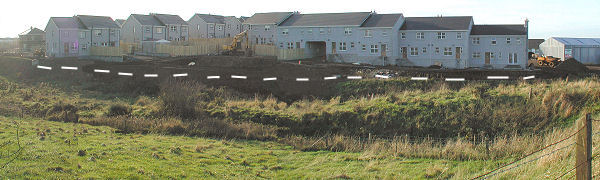
I wonder what buffer he is talking about? Would this be the 2m approx. strip of land running behind the gardens of Nos. 6 to 22 Eagry Park, backing onto the lower field (Site no. 0248)? If so, that strip of land was marked on the second amended plan so nothing has changed. In the original (July 2001) plan the nearest proposed new dwelling at the highest part of the site was 10 metres from the nearest edge of that strip. Now, in the May 2003 "Roads" Drg no 02/55:02 it would appear the strip has been absorbed into the development and the nearest dwelling, at that high point, is 12m approx from the Eagry boundary . A quick sum of 12m minus 2m puts the position of the dwellings in exactly the same place as was originally proposed. CLICK to see an artist's impression of the area to see the crest mentioned.
In the original, July 2001, proposal there were 2 x detached two-storey houses and 3 x bungalows at that crest (23m. OD). However, the "accepted" plan shows those dwellings replaced by a two-storey terrace of four dwellings and 2 x two-storey semi-detached houses. (The bungalows have gone).

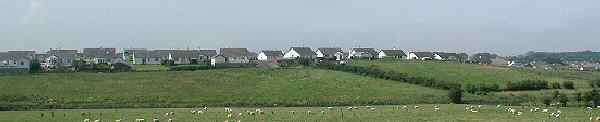
In terms of visual impact of this development, perhaps the most sensitive area for the visitor arriving in Bushmills from Ballycastle along the Straid Road is where the new development "meets" that road.
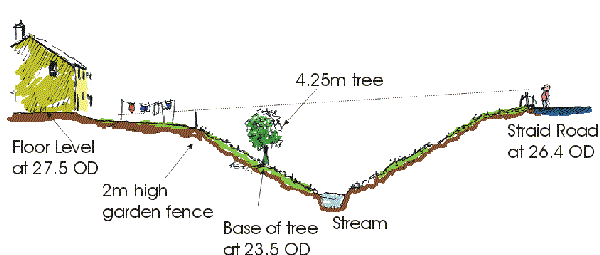
The Landscape plan (received by Planners 13 Feb 2003) for the section of the site nearest the Straid Road shows two rows of trees to be planted between the houses and the road, presumably as a screen. However the row of trees nearest the houses is running along the line of the sewers' "wayleave" (A 6m strip to be kept clear to enable maintenance work). These trees appear to be have disappeared on the "Approved" Roads layout Plan (30/5/03).
However the front row of trees remain. These are to be planted in the dip between the road and the houses. According to my reading of the plan they are to be planted at their highest point on the 23.5 OD contour line. Any higher and they will be in the "no-go" 6m wayleave strip. There are sewers beneath this bank. The dwellings these trees are to screen start at a minimum floor level of 26.8 OD so assuming a maximum tree height of 4.25m then (23.5 + 4.25 = 27.75) these will screen the first metre of brickwork or fence and no more. Here's a scale drawing : -
19/2/02 " The river (St Columb's Rill) has landscape and wildlife value which development proposals should seek to enhance". (My addition in italics). |