| TREES, PLANTS AND WILD FLOWERS |
 |
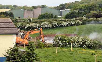
| Photo taken
in the top field (0247) |
| A representative from the Natural Heritage (DOE) confirmed on the phone
(9/5/02) that this area in question is : - |
"One of the few wetland
areas in North Antrim...." |
|
| 2nd
February 1971 marked the date of the signing of the "Convention on Wetlands" in
the Iranian City of Ramsar, when governments
across the world agreed to conserve and make the best possible use of
their valuable wetland resources - Are the Planners,
by approving this development, making "best possible use of our valuable
wetland resources"? A large part of this area is to be covered
in and a road built over it. |
| |
| In the Cross Sections drawing 02/55:05a submitted by the
developer (30 May 2004) it would appear that well over half of this wetland
in the upper field (foreground of the top photo) is to be covered with
up to 2 metres of in-fill. |
| |
| Here is part of a letter from Environment and Heritage Service (Natural
Heritage) to the Planners on 8th July 2002 |
8/7/02
"
The
proposed built development, as indicated in drawing 04, is now
within an
acceptable distance
of the stream. The planting belt should be a minimum width of 10m,
of locally native specimens of Alder and Willow, as these trees
are suitable for wet ground and wildlife.
EHS is concerned that there is adequate
protection of water quality and wildlife in the stream and that in-filling
does not result in sediment release into the stream. Planting of
streamside trees at the earliest opportunity may
protect the stream from sediment run-off." (My emphasis)
|
|
The same lady, when spoken to on the phone on 26/9/02, was adamant
that : -
|
"...no
construction machinery and no workers should be entering the stream
area."
and "....Planners should put these conditions on this development
and enforce it.".
(BUT THEY DIDN'T !)
|
|
Incidentally the above letter from EHS saying 'drawing 04 was acceptable'
referred to the second amended plan (1st July 2002) which in fact showed
two houses still in the wetland flooding area. This oversight had to
be pointed out to the officer.
However, in the above letter the EHS are referring to a plan which
has been superseded. And now the toe of the in-fill embankment on the
Approved
May 2003 drawing
02/55:05a would appear to come to within 4 metres of the stream bank
in several places in the upper field. So we wrote to the planning department
about this anomaly and have since heard back from the Divisional Planning
Manager on 2nd March 2004 as follows :- |
2/3/04
"In view of your queries we will clarify any outstanding issues with
EHS" |
|
| |
| We wrote on 15th March 04 to EHS asking if these outstanding issues have been resolved. As of
17-Oct-2006
apart
from an acknowledgement saying they have received our letter, we never
did get a reply. |
| However, on 27th May we visited the Planning
Department to view the Application Files and there we read a letter from
the Environment & Heritage
Service dated 1st April 2004. Here are some extracts:- |
1 April
2004
"EHS Natural Heritage acknowledges receipt of landscape plan
and cross sections. We have serious concerns with this
amended proposal.
In our responses dated 09/05/02 and 08/07/02,
we requested a 10m no development zone along the stream, which
was to have a planting belt of native species. We are concerned
that the drawings indicate proposed infill within the 10m corridor
and that fencing is proposed along the river edge.
We request amendments to the proposals to
ensure that no infill, development, fencing, ground disturbance
or re-seeding takes place within the 10m zone."
(My emphasis)
|
|
| Are we to assume from the above that (alerted by ourselves, members of
the general public), this is the first time EHS had seen the amended plan?
Methinks someone had slipped up in the planning process yet again. |
| The only response so far to the above requests would appear
to be a letter from the developer's agent (25th May 2004) stating:- |
25/5/04
".......my Clients are agreeable to not erecting a fence along river
indicated on landscape proposals......" |
|
| But no response to the request for - no infilling, development, ground
disturbance or re-seeding. But at least the badgers won't need wire cutters
after all! So much for the following statement... |
2.1. "Regulation
of Development"
"We have a significant influence on the planning process through
the planning applications we receive for consideration and comment"
[NATURAL
HERITAGE STRATEGIC PLAN
Pub. Environment and Heritage Service Sept. 2003] |
|
18th July 2004. The Case Officer wrote (28
May 2004) to
the Divisional Planning Manager, on our behalf, asking, "What's
happening re.
EHS concerns
since EHS made comment on 01 April 2004?" As far as
we know he never got a reply.
|
The Decision Notices were eventually issued (29
June 2004) and there was
no mention of the above request so infilling
, development, ground disturbance and re-seeding has all been allowed
to take place within the requested wildlife 10m zone." There's
a 80m (262 feet ) long road embankment to be built which will run lengthwise
within this
zone.
|
| |
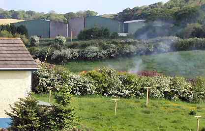
The destruction of the countryside is summed up in these "Before
and After" photos taken on the morning of 24th May 2004. (The hedge
between sites 0248 and 0247).
I wonder how long this hedge has been here? Were there birds nesting in this
hedge? |
|
| |
|
| Under the Wildlife
(NI) Order 1985, it is offence
to damage or destroy the nest of any wild bird whilst it is being used
or built, or disturb any wild bird while on or near a nest that is being
built. And under Good Farming Practice the trimming of hedges is not permitted
from 1st March until 31st August. These photos were taken on 24th May. |
"Removal of field boundaries is not permitted except
by prior written permission from DARD"
"Good Farming Practice" leaflet, published
by Dept. of Agriculture and Rural Development 2004 |
|
As of
17-Oct-2006
some 50m of mature hawthorn hedge has been ripped out
and, as mentioned elsewhere, the plans show at least a metre of soil
to be
dumped over a large part of the existing wetland.
|
2.01 "The characteristics of the site
should be analysed to ensure that the development will: - Make the
best
use
of existing vegetation and
protect or create appropriate conditions for flora and fauna to survive
"
"Creating Places" (Achieving quality in
residential developments) Booklet
pub 2000 by Planning and Roads Service |
|
| The 40 metres of the hedging which has been removed curiously appears
as part of the final landscape proposals for the site |
2.21 The appropriate retention of existing
vegetation and its enhancement with new planting
will help to integrate development into its setting
.... and will be a major determinant of the layout" (my
emphasis)
"Creating Places" Booklet pub
2000 by Planning and Roads Service |
|
| We tried to give a letter of protest about this hedge destruction to
the "Boss" of the builders on the site (He wouldn't give
his name), but
he refused
to
accept it.
So instead
we sent it to the firm's home address. CLICK to read a copy of the letter. |
| << Return to first page of Eagry |