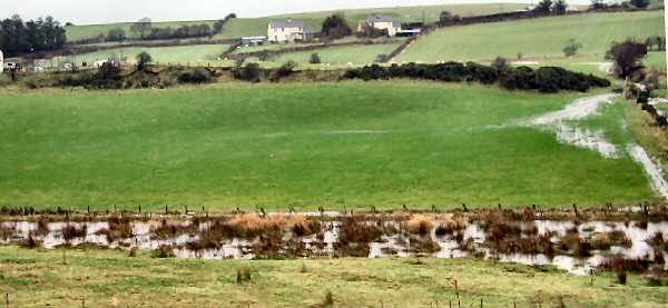
This photo was taken on 29th November 2003, just five days
after Moyle Council accepted the planners agreement for the Developer to
build on the site which appears in the foreground.
In June 2002 our four local Councillors and the then chairman of Moyle Council were each sent photos of previous examples of the flooding so they were aware of the problem. Yet none spoke out when this development came up for approval on 24th November 2003.
| 15/8/01 " Rivers Agency is opposed in principle to any in-filling for development purpose, in areas of flood pondage, as the resultant displacement of flood water can cause problems elsewhere within the catchment." |
Planning Policy Guidance 25 is a DoE consultation paper which applies to England only -- but our water is just as wet as theirs! Here are a few extracts from that 45 page document
"Local
planning authorities should use their existing powers to guide,
regulate and control development
in areas at risk of flooding….The
susceptibility of land to flooding is a material consideration
in determining planning applications ......The potential consequences
for occupiers in terms of personal and financial risk can be serious.......The
principal cause of river flooding is excessive rainfall or snow
melt within a limited period…. the impacts can be
aggravated by… the growth of built development in
catchments which increase the rate and volume of run-off." (My
emphasis) |
You can see the whole PPG25 document in pdf form by clicking HERE
| "HOME
INSURER REMOVE FLOOD AREA COVER Owners of homes built on flood plains or in areas prone to repeated flooding will no longer be able to get cover from one UK insurance company. Internet based firm ESURE said the move would potentially cut costs for millions of householders by limiting the locations it will involve. CEEFAX 12th June 2002" |
"In
relation to the flood plain he had removed a couple of dwellings
and has used the area for public open
space. Part of the estate road also is over these lands"My
emphasis |